Any map geeks in here?
-
- Posts: 10719
- Joined: Feb 12, 2006 12:00 PM
- Location: CHI, IL
Any map geeks in here?
I have always loved maps. My parents figured out pretty early on that they could keep me quiet for hours by sticking an atlas in front of me. I think that's a big reason I love road trips so much; I used to stare at the atlas and wonder what every place was like. Maps also are a phenomenal way to look at data of different types.
I saw this today, very cool: http://www.wired.com/design/2013/08/how ... eid-210501
In the snapshot of (most of) the US, you can see a band of black population that is roughly U-shaped and curves through the north and east of the Mississippi Delta region, through MS, AL, and GA.
It reminded me of this article, which, while vaguely political, is mostly about geology and therefore this post isn't intended for the TP. Pretty amazing that the lay of ancient beaches results, via slavery, in a demographic pattern still apparent 150 years after the Civil War.
Other interesting stuff:
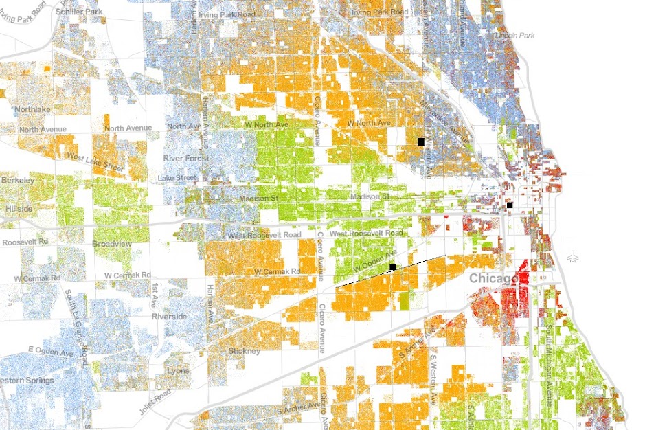
I drew three boxes on this in black. The northern/western box is where I currently live. You can see the N/S street immediately to the east is a dividing line of sorts. Identical homes to mine on the east side of that street cost ~20% more than we paid for ours immediately west.
To the south and west, the black box is the vicinity of the shop I rent storage space in for the track car and related stuff. The very sharp dividing line between Latino and black neighborhoods is a physical train track (I drew the line in where the track runs). Pretty amazing that such barriers that are easily crossed create such stark divisions (the train is elevated). Side note, to the east and south of the shop is a square that is mixed Latino and black. That's Cook County jail, the largest in the nation.
Finally, the center/east dot is where I lived until recently. Relatively sparsely populated as it's a pretty business-heavy district, but condo buildings are going up right and left there so I expect it will look very different at the next census. Highly integrated area ethnically, though.
More random map fun here: http://twistedsifter.com/2013/08/maps-t ... the-world/
-tammer
-
- Posts: 6135
- Joined: Aug 05, 2007 4:57 PM
- Location: 24477
-
- Beamter
- Posts: 23035
- Joined: Apr 08, 2009 10:30 PM
- Location: Charlottesville, VA
- Contact:
Another interesting compilation of maps that turns toward political (but is interesting nonetheless.)
http://www.washingtonpost.com/blogs/wor ... the-world/
-
- Posts: 2046
- Joined: Feb 12, 2006 12:00 PM
- Location: Marquette, MI
I like topographic maps. My favorite way to explore - using them. Of course the ones with many elevation changes and varying terrain seem to be the coolest. Enjoy finding innocuous little things written on the map and finding them in the flesh.
Seems like the old standard Atlas, the most commonplace of maps, is dead these days, with the advent of GPS. Is this the case in other areas of mapping, I wonder? So many maps, so little time....
-
- Posts: 6135
- Joined: Aug 05, 2007 4:57 PM
- Location: 24477
I will waste hours on Google maps finding little niches and oddball places in my area. Like the train tunnels from the Civil War era, and odd named places like the Devil's Marbleyard.Minotaur wrote:I like topographic maps. My favorite way to explore - using them. Of course the ones with many elevation changes and varying terrain seem to be the coolest. Enjoy finding innocuous little things written on the map and finding them in the flesh.
-
- Posts: 10719
- Joined: Feb 12, 2006 12:00 PM
- Location: CHI, IL
Back in 1999, I was doing geology research out west. We were navigating BLM land with topo maps and Brunton compass--it was a blast. There are definitely areas where GPS coverage is spotty or ability to orient to local landmarks (water gaps, hills) will be more reliable. But who knows, it probably is a dying technology and skill set overall, which is too bad.Minotaur wrote:I like topographic maps. My favorite way to explore - using them. Of course the ones with many elevation changes and varying terrain seem to be the coolest. Enjoy finding innocuous little things written on the map and finding them in the flesh.
Seems like the old standard Atlas, the most commonplace of maps, is dead these days, with the advent of GPS. Is this the case in other areas of mapping, I wonder? So many maps, so little time....
-
- Posts: 254
- Joined: Aug 13, 2011 7:36 PM
- Location: Virginia
I studied geology at Virginia Tech and worked in the map department at the university's library while I was there. Pretty serious collection of maps....
Then pulled a stint doing geology research in the backwoods of Alberta, B.C., and southern Alaska, which involved generating topo maps by hand. That was a pretty epic time---having all our supplies flown in, traveling for weeks by boat on inland lakes, etc.
I was always more of a physical geology guy, so I always thought this map was pretty cool. I still have a 3' x 5' version of it.
http://www.nature.nps.gov/geology/usgsn ... /quiz.html
Fascinating; I too can waste hours in front of maps.
It reminds me of a museum exhibition I saw decades ago at the Cooper in NYC about maps. Specifically it showed different and/or unusual maps, ones that challenged our perception over the conventional maps we were raised with (i.e. either NA centric or polar oriented). One of the maps I still recall vividly was the view of the rest of the North America looking south from Alaska, shown as if you were standing on a mountain looking back south (kind of a horizon perspective). Turns your whole perception of the world and mapping convention on its' head.
Los Angeles was interesting but not surprising: all the white people live in the hills or on the coast. Most cities since the dawn of time evolved this way (under the general assumption that those are where the wealthier groups in society are grouped). What was a bit shocking was the almost complete transformation of the San Fernando Valley, that large area at the top of the LA maps, just above the white band on the Santa Monica Mountain range (Bel Air, Beverly Hills, Hollywood Hills, Malibu). Back in the '50's thru the '80's it was a predominately white suburb. White flight happened in the subsequent decades to the next ring of "valleys" beyond them (Santa Clarita, Simi, San Gabriel, etc.). SFV is almost all Hispanic now.
-
- Posts: 2046
- Joined: Feb 12, 2006 12:00 PM
- Location: Marquette, MI
I can be happy if I never see another map, just knowing I have something in common with you, Tammer. To beat a dead horse, I really enjoy navigating with maps, and take a certain pride in it. Some folks struggle with them. I'll bet that job was awesome! Your job too, CharleyDog!! Epic employment!!
"We're afraid you're going to hurt somebody...WE'RE AFRAID YOU'RE GOING TO HURT YOURSELF!!"oldskool wrote:When I was younger, all I wanted was a Pepsi. And they wouldn't give it to me.
If I had a nickel for every minute I've spent poking around in Google Earth or poring over other maps...
When our kids were little, my wife had a number of different maps that she would put under a clear tablecloth on the kitchen table; world map, US map, Africa, Asia, Europe, Malaysia/Indonesia/Australia... She would rotate through them periodically & at meal times (or any time around the table) we would play games with the kids to help us all learn something about what was on the maps. The kids still bring that up.
We left for our most recent road trip with a GPS but without a map or atlas; we ended up buying a Colorado map because not having one almost made my wife crazy. I wasn't far behind.
-
- Posts: 9472
- Joined: Feb 12, 2006 12:00 PM
- Location: Minneapolis
I do logistics and routing for a living, so I guess I like maps. I might even be doing work on logistics for the Spartanburg plant soon, if all goes well.
Oh, just stop it you old farts. Besides, I WANT MORE!Minotaur wrote:"We're afraid you're going to hurt somebody...WE'RE AFRAID YOU'RE GOING TO HURT YOURSELF!!"oldskool wrote:When I was younger, all I wanted was a Pepsi. And they wouldn't give it to me.
-
- Beamter
- Posts: 23035
- Joined: Apr 08, 2009 10:30 PM
- Location: Charlottesville, VA
- Contact:
So we decided that it would be in your interest if we put you somewhere where you could get the help that you need.Minotaur wrote:"We're afraid you're going to hurt somebody...WE'RE AFRAID YOU'RE GOING TO HURT YOURSELF!!"oldskool wrote:When I was younger, all I wanted was a Pepsi. And they wouldn't give it to me.
We decided? My best interest?? How can you know what MY best interest is????mooseheadm5 wrote:So we decided that it would be in your interest if we put you somewhere where you could get the help that you need.Minotaur wrote:"We're afraid you're going to hurt somebody...WE'RE AFRAID YOU'RE GOING TO HURT YOURSELF!!"oldskool wrote:When I was younger, all I wanted was a Pepsi. And they wouldn't give it to me.
I spent a few years doing back country archaeological surveys and off the grid camping, so I learned to navigate with maps and compass. I do still enjoy maps as well, and I have an original 1887 plot of my neighborhood in DC in my office.
I do some disaster preparation work as well, and enjoy planning escape routes out of the city based on various factors.
Interesting stuff.
I do some disaster preparation work as well, and enjoy planning escape routes out of the city based on various factors.
Interesting stuff.
What are you trying to say, I'm crazy? When I went to your schools, I went to your churches, I went to your institutional learning facilities?! So how can you say I'm crazy?!slack wrote:We decided? My best interest?? How can you know what MY best interest is????mooseheadm5 wrote:So we decided that it would be in your interest if we put you somewhere where you could get the help that you need.Minotaur wrote:"We're afraid you're going to hurt somebody...WE'RE AFRAID YOU'RE GOING TO HURT YOURSELF!!"oldskool wrote:When I was younger, all I wanted was a Pepsi. And they wouldn't give it to me.
On topic: I love a good atlas. Good maps are so much better for trip planning than a GPS. GPS is a great tool when you're already out traveling though. I do prefer triangulating my position when I'm out hiking. Orienteering was a talent of mine.
I agree! Older charts from early explorers and civilizations are fascinating. Image the technology available to them and the end result that was still produced.turbodan wrote:Maps are cool. Especially old maps.
I spent hours glued to an atlas as a kid. Photographs of features or terrain were not readily available like they are today. Imaging what they looked like took me deeper into other book in the library. And when I couldn't find a photo, there was always my imagination.
Still today, i choose to use a chart. Although most of the hiking trails are in GPS databases, there is nothing like a topo and a compass. We head off for a backpacking trip in Wyoming in September. The compass and charts are already packed!
-
- Posts: 10719
- Joined: Feb 12, 2006 12:00 PM
- Location: CHI, IL
I've enjoyed this discussion so far. I guess it doesn't surprise me that many of us find maps interesting.
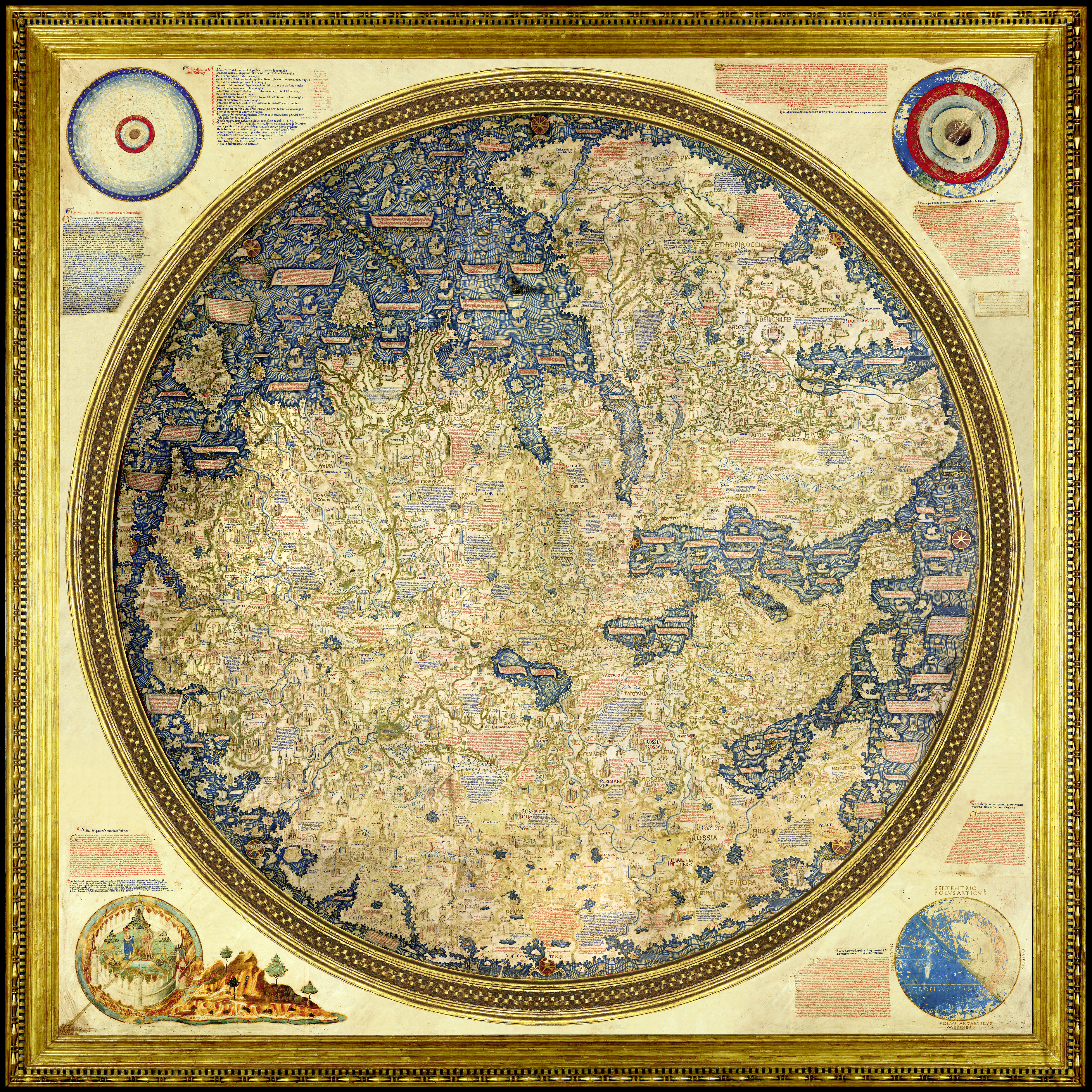
Speaking of old maps, Dan, in the Galileo museum of scientific tools in Florence, Italy there is a map of the world ca. 149\50. As you might expect, Rome is oriented near the center. The map is round and a flat projection, as most people believed that's how the world looks. When you take away the spherical nature of the globe, some weird shit ends up next to each other. Also, it was both amazing how right they had the Mediterranean coast, and how wrong they had just about everything beyond present-day Turkey.
<searching for image online ...>
Man, the internet has everything!
-
- Posts: 254
- Joined: Aug 13, 2011 7:36 PM
- Location: Virginia
-
- Posts: 10719
- Joined: Feb 12, 2006 12:00 PM
- Location: CHI, IL
That ^^^ is cool.
As a follow-up to this, I got online to find my (new to me as I've moved) Congressional rep and write to them to voice opposition to a move in Syria.
What I saw for my district map looked familiar:
Look familiar? See that N/S line dividing the blue district from the red district? That's the same street I live just west of in this map:
Note how the district curves around to pick up all the Latino population, even that which is 4 miles away south of where the shop is (marked in the 2nd map). Guess which rep pictured is mine, and guess which one represents the district to the east and north? Further, guess the race of the representative in the "middle of the sandwich!
Frickin' crazy.
I thought this was interesting; video depiction of how borders in Europe have changed over the last millennia.
http://www.liveleak.com/view?i=f54_1337075813
That is interesting. What it really needs is a running timeline with the year and the names of whatever major events are transpiring. That would let it slow down during periods of upheaval so we can see what's happening.davintosh wrote:I thought this was interesting; video depiction of how borders in Europe have changed over the last millennia.
http://www.liveleak.com/view?i=f54_1337075813