Page 4 of 5
Posted: May 13, 2014 11:16 PM
by davintosh
Jeremy wrote:davintosh wrote:You keep right on sipping that bourbon & bumping the averages up, Jeremy. Just don't rely on your reading comprehension when you do.

Seriously. Where was the link to the article? I must be blind, cause I don't see one.

Click the image. Or this link.
 http://www.independent.co.uk/life-style ... 57860.html
Posted: May 15, 2014 2:30 PM
by unt0uchable
davintosh wrote:
Damn! You stole my post! lol
Re: Any map geeks in here?
Posted: Jul 25, 2014 1:51 PM
by Jeremy
Nothing special, but this one's been making the rounds on Facebook.
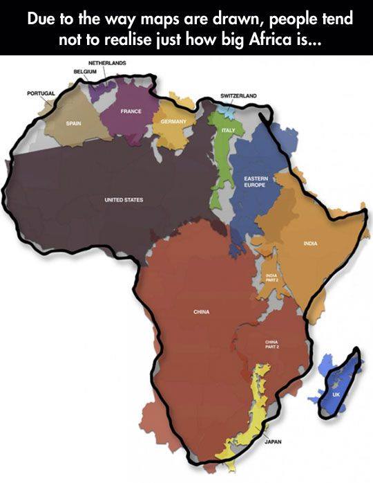
I knew how big Africa was, but that really puts it in perspective. One of the comments was this clip from West Wing. The video quality is poor, but I found the whole thing amusing.
https://www.youtube.com/watch?v=n8zBC2dvERM
Re: Any map geeks in here?
Posted: Jul 25, 2014 3:38 PM
by Tammer in Philly
Yeah, the Mercator projection has some real limitations.
Re: Any map geeks in here?
Posted: Jul 25, 2014 3:49 PM
by clangpap
I missed this thread last year, but it was still a fun read. My Father showed me my Grandfather's school atlas (born N.D. 1883) when I was young, and I was stunned at the changes in the US alone. Oklahoma was divided vertically into Government land and Indian Territory. That really stuck with me and I've been interested in maps both modern and ancient since. Like Tammer, when in Europe I'm drawn to the map rooms in the large museums showing how the world was depicted hundreds of years ago when discovery was fresh. If you ever have the chance, visit the Medici hall of maps in the Plazzo Vecchio in Florence. The maps of the then-known world are painted, many by Dante. He also made the enormous iron globe in the room.
Re: Any map geeks in here?
Posted: Aug 31, 2014 2:31 PM
by davintosh
Here's one that surprised me; the top 30 US counties with the highest percentage of residents that keep firearms around their homes. South Dakota is home to two of the top 30. Pennington County -- on the west side of the state and home to Rapid City, most of the Black Hills, and Mount Rushmore -- isn't a huge surprise. West River SD is very wild-west, but Minnehaha County? That's where I live. I live near many people who would be very bothered by that statistic. Not that they should be...
But the rest of the map is also pretty surprising; I would've expected more of them to be in the South.

But the fact that Florida looks like a pistol that's pointed right at Louisiana helps explain why LA is home to six of the counties on that list.

 http://www.theblaze.com/stories/2014/08 ... prise-you/
Re: Any map geeks in here?
Posted: Aug 31, 2014 8:12 PM
by Karl Grau
davintosh wrote:I would've expected more of them to be in the South.
Me too, and not even in
one in Texas...

Tammer in Philly wrote:Yeah, the Mercator projection has some real limitations.
In the context of its time, it was the best for navigation.
Re: Any map geeks in here?
Posted: Sep 12, 2014 11:29 AM
by MicahO
Here's a map of nerds, for the map geeks.
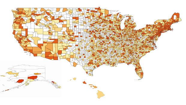
White indicates that no Wikipedia edits were recorded for that county, and darker color indicates higher edit rates.
http://www.datainnovation.org/2014/09/w ... a-deserts/
Re: Any map geeks in here?
Posted: Sep 12, 2014 6:12 PM
by Karl Grau
I bought this map in the mid '80s, lost it in the early '90s and replaced it this week.

You can see the Grau clan seemed to like the suburbs of Dundee.
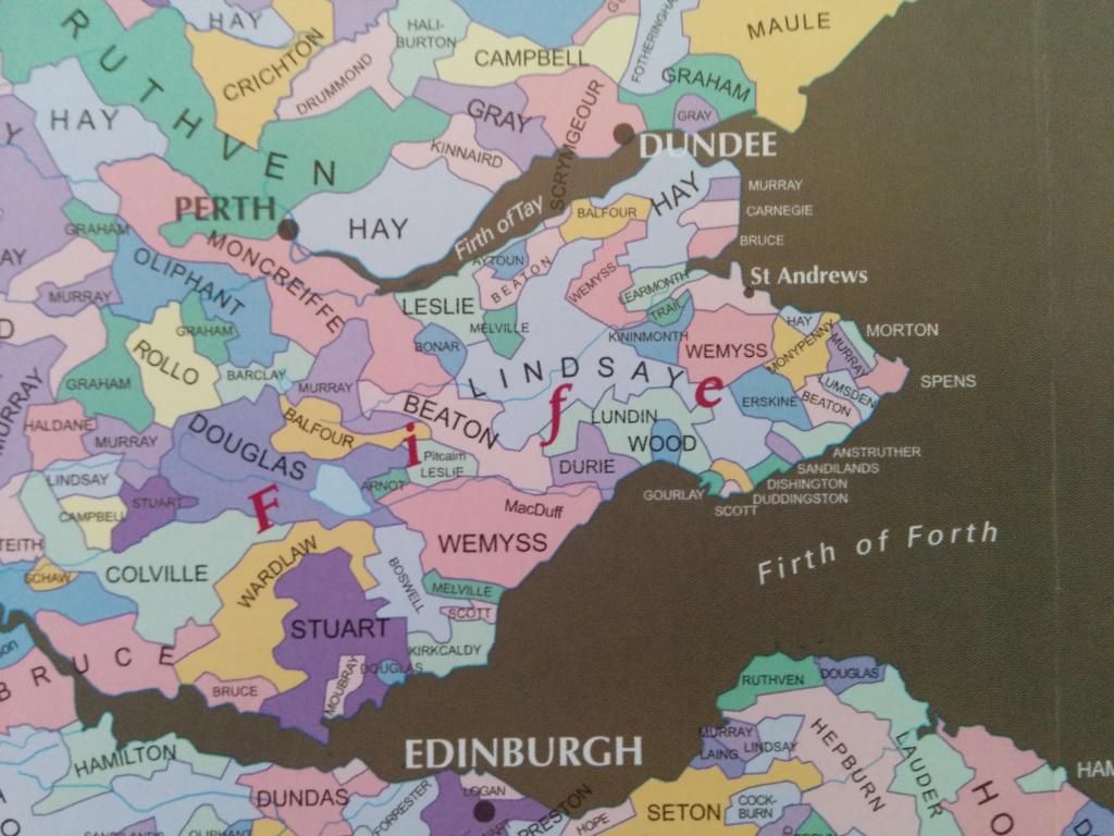
I always wondered if the motto means Anchor securely or "Holy shit, drop that anchor NOW!".
(BTW, I would like to addressed as
Lord Gray henceforth)

Re: Any map geeks in here?
Posted: Sep 18, 2014 1:22 AM
by Tammer in Philly
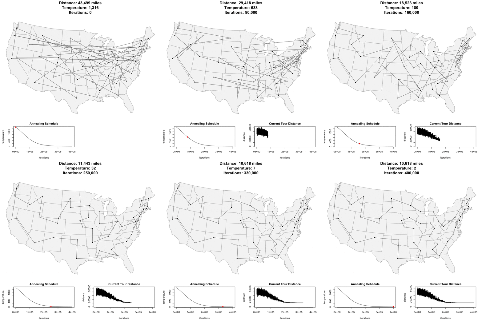
Finding shortest route to travel through the Lower 48
Re: Any map geeks in here?
Posted: Sep 18, 2014 12:14 PM
by ldsbeaker
That looks like all of the state capitols... Wish it was road miles rather than "as the crow flies".
Re: Any map geeks in here?
Posted: Sep 18, 2014 1:33 PM
by davintosh
ldsbeaker wrote:That looks like all of the state capitols... Wish it was road miles rather than "as the crow flies".
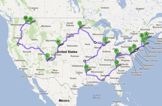
And of course, someone else thought of that already...
http://www.datapointed.net/2012/08/fast ... ed-states/
http://goo.gl/maps/W81gu
Re: Any map geeks in here?
Posted: Sep 18, 2014 8:17 PM
by Tammer in Philly
I'd like to modify that to make it a loop rather than point-to-point, and it looks like Chicago would be a good start/ finish line for a 48-state loop.
Hmmm ...
Re:
Posted: Sep 19, 2014 12:22 AM
by Mike W.
davintosh wrote:

If the average consumption in the US is 7.5 to 9.9 liters per person per year, somebody is working their liver overtime to make up for me. I rarely drink anything stronger than beer, and that only a couple/three times a week. Anybody ready to 'fess up?

Just slightly delayed, but what the h. A very good friend of mine did his damnest to make up for your limited consumption. He was going thru a 5 L box of wine a day.

The math comes out to something like 240 L per year which goes a long way to making up for lightweights. Unfortunately he only had a limited number of years doing that.

Which actually brings up a slightly more serious observation, there are quite a few very heavy drinkers out there and they go a long way to skewing the numbers.
Re: Any map geeks in here?
Posted: Dec 04, 2014 8:48 PM
by davintosh
Found another interesting one, weather related:
Which City Has The Most Unpredictable Weather?

They say if you don't like the weather in South Dakota, just give it a few minutes and it'll change. I guess this is proof of that. Rapid City, SD, has the most unpredictable weather in the country with an "unpredictability index" of 84. Two other SD cities are in the top 10; Sioux Falls at #4 and Aberdeen at #8. At the opposite end of the spectrum are Honolulu and San Diego. Why is it that SD never makes it into top ten lists that don't suck? Wait; don't answer that.
Re: Any map geeks in here?
Posted: Dec 05, 2014 10:08 AM
by Jeremy
davintosh wrote:They say if you don't like the weather in South Dakota, just give it a few minutes and it'll change.
Funny, I'd always heard that about New England weather too. We got a few entries on there, but not nearly as bad as you guys have it apparently. At least our temperatures are moderately predictable, even if the weather patterns aren't. We do have a joke that there is no such thing as an "average winter" in Connecticut. It either snows way more than average, or way less.
Re: Any map geeks in here?
Posted: Dec 15, 2014 10:42 AM
by unt0uchable
Found this one interesting.
http://www.vox.com/2014/12/12/7377541/m ... r-happened
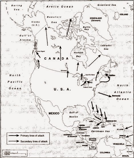
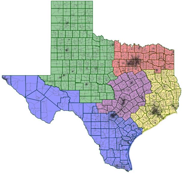
A few more in there are neat.
Re: Any map geeks in here?
Posted: Apr 02, 2015 2:55 PM
by Tammer in Philly
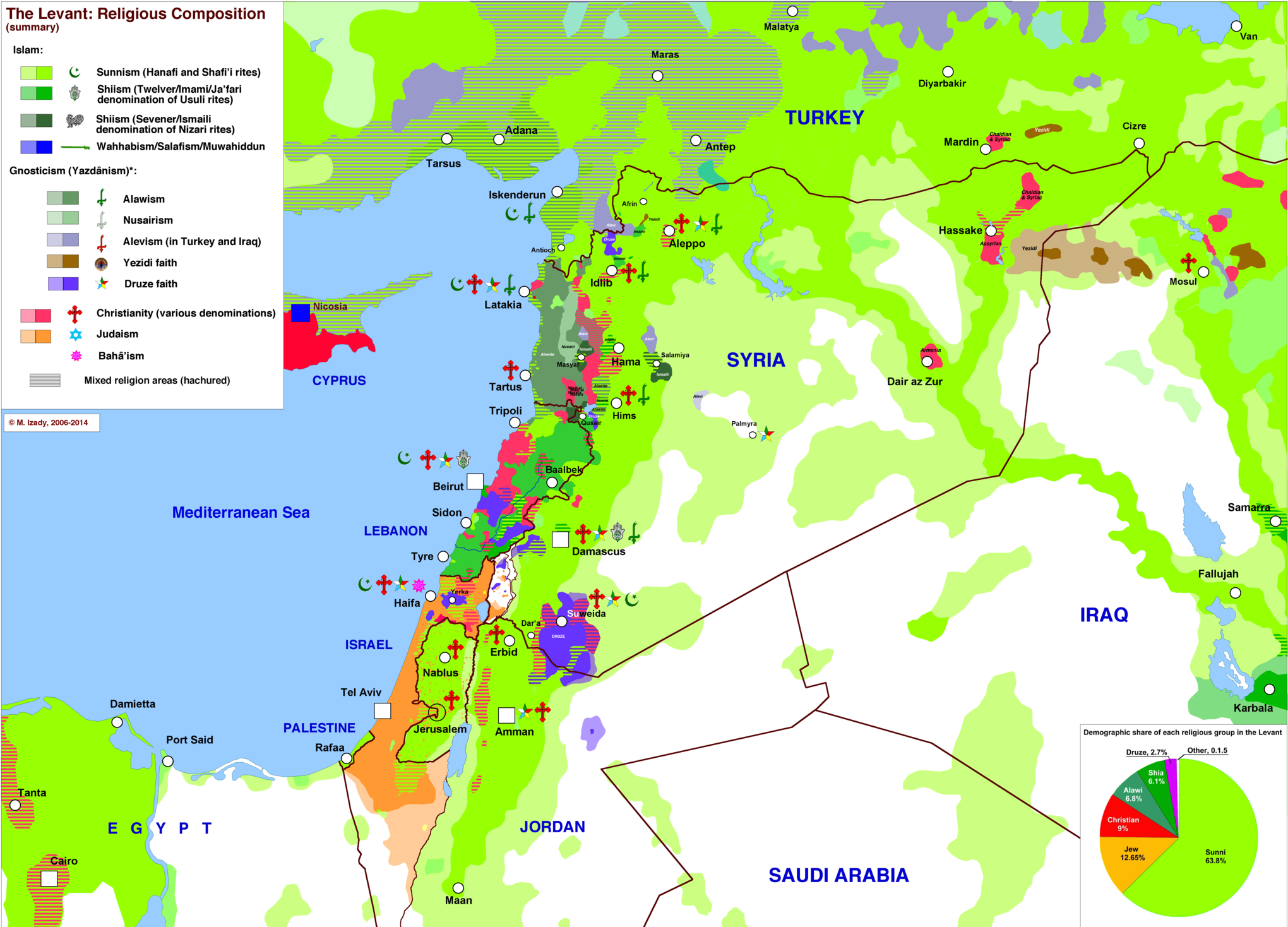
Another great article full of maps on Vox
http://www.vox.com/a/maps-explain-the-middle-east
Sample:
Re: Any map geeks in here?
Posted: Nov 28, 2015 7:33 PM
by Jeremy
Is it legal to do X while driving?
https://www.justpark.com/creative/is-it ... 8f8bcb1d66
Spoilers - Apparently it's still legal to drink and drive in Missouri, and very few states prohibit traveling in the left lane. I can vouch for the fact that, even though that's not legal in Massachusetts, people do it there just as much as in neighboring states regardless.
Re: Any map geeks in here?
Posted: Nov 29, 2015 9:13 PM
by Sapotorito
Fascinating thread... interesting and full of resourceful information. I spent a great part of my day today reading the posts and exploring the maps

Re: Any map geeks in here?
Posted: Nov 30, 2015 7:00 AM
by Shawn D.
Jeremy wrote:Is it legal to do X while driving?
https://www.justpark.com/creative/is-it ... 8f8bcb1d66
Spoilers - Apparently it's still legal to drink and drive in Missouri, and very few states prohibit traveling in the left lane. I can vouch for the fact that, even though that's not legal in Massachusetts, people do it there just as much as in neighboring states regardless.
Good info for road trips -- thanks!
Re: Any map geeks in here?
Posted: Dec 02, 2015 11:11 PM
by no2tracks
Shawn D. wrote:Jeremy wrote:Is it legal to do X while driving?
https://www.justpark.com/creative/is-it ... 8f8bcb1d66
Spoilers - Apparently it's still legal to drink and drive in Missouri, and very few states prohibit traveling in the left lane. I can vouch for the fact that, even though that's not legal in Massachusetts, people do it there just as much as in neighboring states regardless.
Good info for road trips -- thanks!
It looks like Mississippi, not Missouri.
Re: Any map geeks in here?
Posted: Oct 25, 2016 3:06 PM
by Karl Grau
Re: Any map geeks in here?
Posted: Oct 26, 2016 2:49 PM
by Tammer in Philly
I like that, but travel times aren't commensurate due to differences in traffic density and topography.
I have been looking for a good/ accurate print of this map lately:
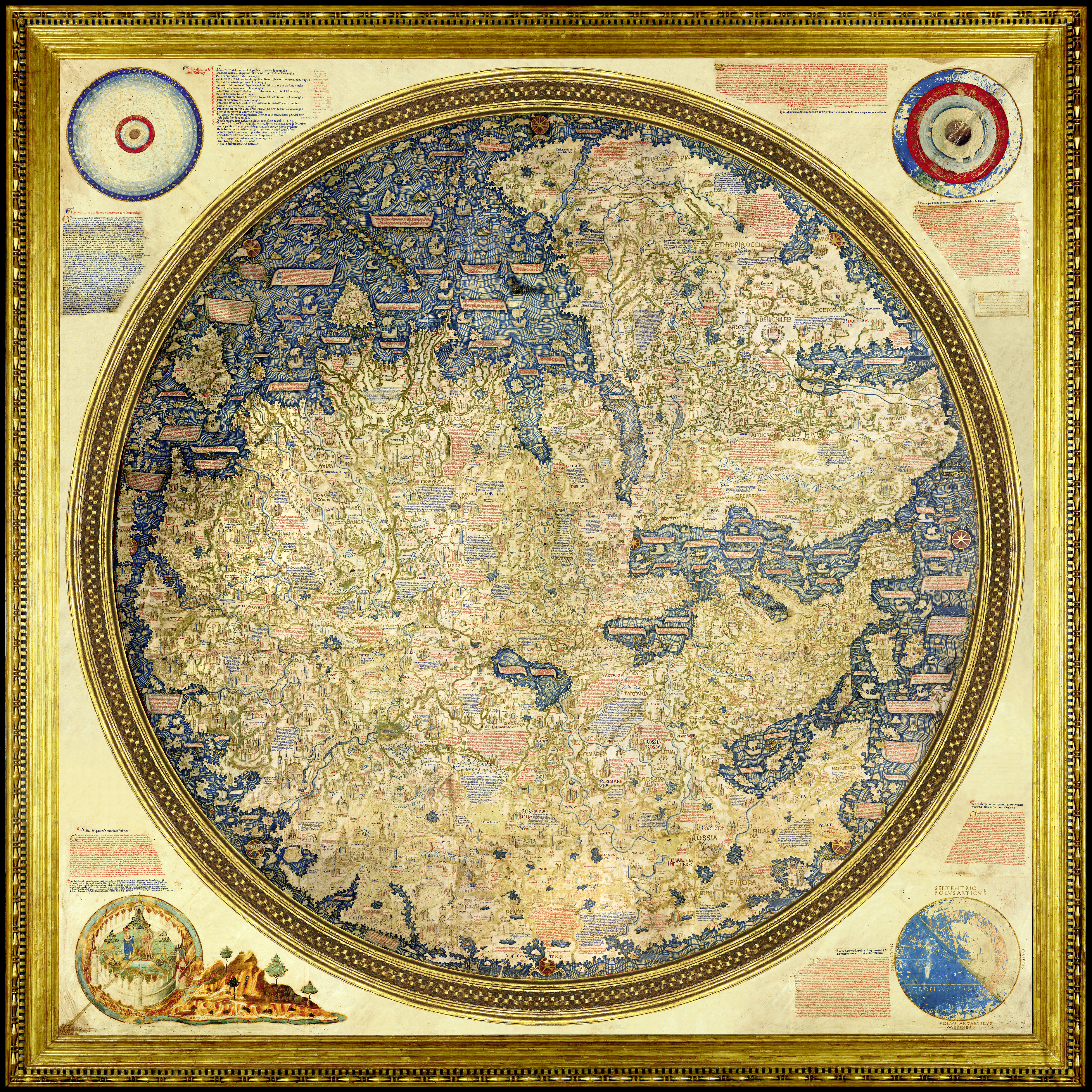
More info:
https://en.wikipedia.org/wiki/Fra_Mauro_map
I saw the original at the Galileo Museum in Florence back in 2006 or 2010, I forget which trip. I believe it was on loan at the time, and the Wiki link suggests it lives in Venice. I love how relatively accurate the map is (note that south is up) given how limited travel and other capabilities were at the time.
-tammer
Re: Any map geeks in here?
Posted: Aug 15, 2017 5:16 PM
by Sapotorito
I ran into this TED talk.. perfect for this thread... enjoy!
https://www.ted.com/talks/danny_dorling ... l%20issues
Re: Any map geeks in here?
Posted: Aug 20, 2017 5:23 PM
by Tammer in Philly
Pretty cool.
Re: Any map geeks in here?
Posted: Aug 20, 2017 8:35 PM
by Karl Grau
Largest non-government employers by state:


Re: Any map geeks in here?
Posted: Aug 23, 2017 10:26 PM
by Jeremy
How the heck is a state run college "non-governmental"?
Re: Any map geeks in here?
Posted: Aug 25, 2017 6:51 PM
by jhh925
Karl Grau wrote:Largest non-government employers by state:

Jeremy wrote:How the heck is a state run college "non-governmental"?
This map was posted at Reddit, where some readers noticed that the map had been posted on April 1st, and suggesting that the map was in part at least an April Fools Joke. Other Redditors noted other errors for other states.
Regardless, here's a link to
the article discussing how the map was put together. Nearly all of the universities / colleges shown on the map are state goverment institutions, but the creators of the map handled them differently:
"For the purposes of our analysis, we treated state government employers like public universities as independent organizations, in keeping with how states frequently identify and compare company headcounts."
I think the idea was that the universities are gov't funded and the faculty & staff are state employees, but in keeping with the idea of academic freedom, they operate independently.
Re: Any map geeks in here?
Posted: Aug 25, 2017 7:49 PM
by Karl Grau
jhh925 wrote:I think the idea was that the universities are gov't funded and the faculty & staff are state employees, but in keeping with the idea of academic freedom, they operate independently.
I'm glad you answered because I had nuthin'...

